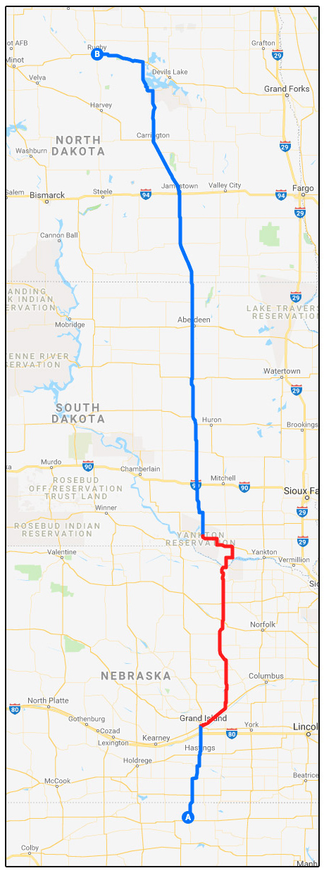
Due to a bridge washout this spring, US Route 281 is closed at the Neobrara River, just south of Spencer, NE. With less than three weeks to go until Smackdab 2019, the closest alternative bridge over the river on State Hwy 11 near Butte NE is currently also closed due to flooding. The recommended alternate route [shown in red on the map above] is to divert from US 281 at Grand Island NE, take US 30 to NE 14, and cross the Niobrara River over the Chief Standing Bear Memorial Bridge, then wiggle your way back to 281 north of Wagner. You can then follow the usual route all the way up to US 2 at Devil’s Lake. This route is all on US and State highways—no big Interstates and no tiny, rough back roads. From Google Street View, these roads look very nice. This detour only adds about 13 additional miles to the ride.
For those who want to explore the route, here is a Google MyMaps link to the suggested alternate route for this year’s run:
https://drive.google.com/open?id=1XYkkfREptgY_zfpiv3c8e6kFsIv-d-Tj
You can also download a KML/KMZ file from the link to import into your GPS.
Further discussion of routes and detours is ongoing in our Facebook group.
| Smackdab 2019 Recommended Alternate Route – 688 mi, 11H:46M | |||
| START: Geographic Center of the Contiguous U.S. Monument, Lebanon KS 66952 | |||
| ROUTE | DIR | DIST | THEN… |
| Head east on KS-191 | East | 1.0 mi | Turn LEFT onto US-281 N |
| Follow US-281 | North | 81.6 mi | Turn RIGHT onto US-30 E |
| Follow US-30* | East | 24.7 mi | Turn LEFT onto NE-14 N |
| Follow NE-14 | North | 122.0 mi | Cross the Missouri River into SD |
| Follow SD-37 | North | 20.6 mi | Turn LEFT onto SD-50 |
| Follow SD-50 | W & N | 31.2 mi | Continue STRAIGHT to rejoin US-281 |
| Follow US-281 | North | 372.7 mi | Turn LEFT onto US-2 |
| Follow US-2 | West | 34.1 mi | ARRIVE |
| END: Geographical Center of North America Monument, 272 US-2, Rugby ND 58368 | |||
| *US-30 splits into two 1-way streets in Grand Island | |||
|
THESE DIRECTIONS ASSUME YOU CAN WATCH FOR AND FOLLOW ROUTE
SIGNS! Routes can turn unexpectedly at intersections and sometimes run concurrently with local street names and sections of other US/State highways. |
|||
These instructions can also be downloaded as an image for easy printing:
2019-Smackdab-Alternate-Route-w-Map.jpg
DISCLAIMER: This route has been developed solely from online resources. A reasonable amount of effort was put into researching these roads, but nobody has actually ridden the whole thing from end to end yet. There may be some surprises along the way on the day of the ride; you are the only one ultimately responsible for your safety and for figuring out how to reach the destination. Use common sense and do some reality checks along the way.